
Most people shopping for a home spend their time worrying about school districts, commute times, and kitchen layouts. Geology rarely makes the shortlist. Yet the ground beneath a property can be as consequential as any feature inside it, and in many parts of the United States, that ground is quietly cracking under the weight of long-ignored seismic risk.
Nearly three quarters of the United States could experience a damaging earthquake, according to the latest U.S. Geological Survey National Seismic Hazard Model, putting hundreds of millions of people at risk across the country. That figure surprises most buyers, who tend to assume earthquake danger is a California problem. The reality is both more complicated and more geographically widespread than the real estate market typically acknowledges.
The USGS Map That Redrew the Risk Picture
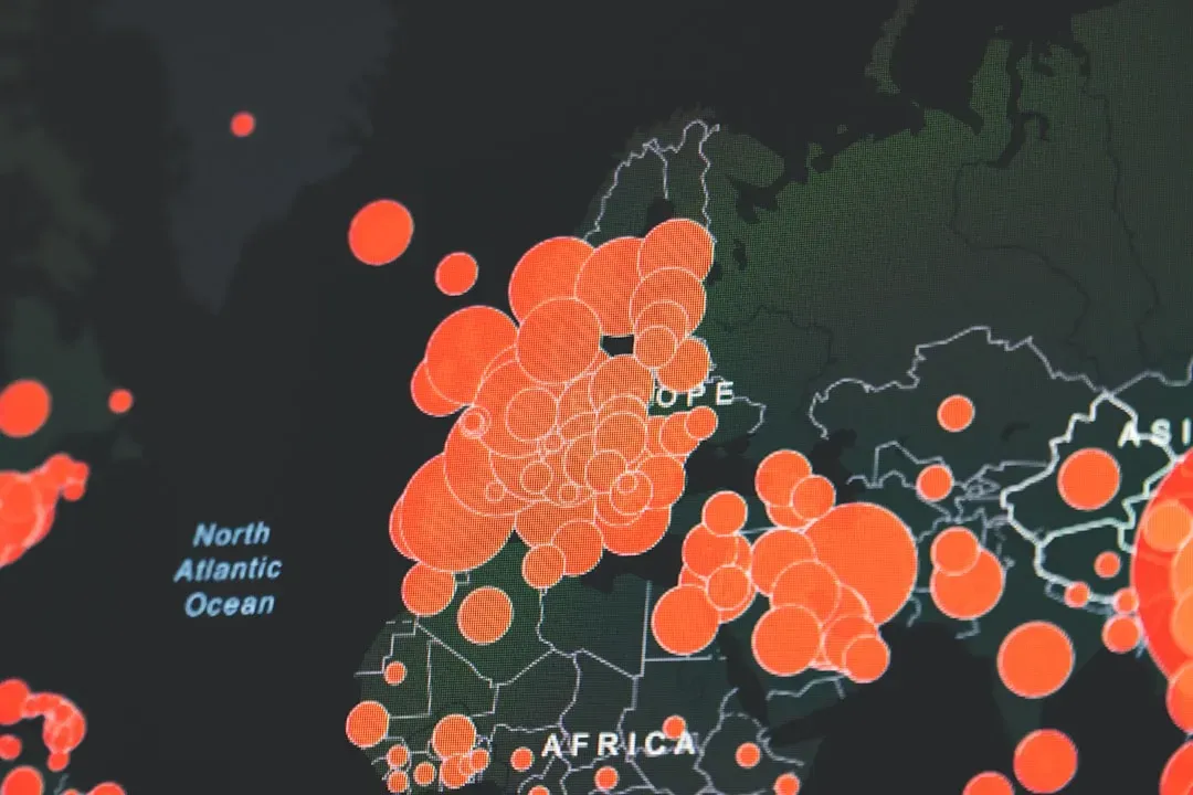
The 2023 fifty-state update of the U.S. National Seismic Hazard Model defines the potential for earthquake ground shaking for various probability levels across the contiguous United States, Alaska, and Hawaii, and is applied in seismic provisions of building codes, insurance rate structures, risk assessments, and other public policy. This was no minor revision. It represented a comprehensive overhaul driven by new data, better modeling tools, and a deeper understanding of active faulting.
New tools and technology identified nearly 500 additional faults that could produce a damaging quake, showcasing the evolving landscape of earthquake research. Thirty-seven U.S. states have experienced earthquakes exceeding magnitude 5 during the last 200 years, highlighting a long history of seismic activity across the country. For buyers in regions they assumed were geologically stable, that is not reassuring news.
The East Coast Surprise: Cities Nobody Expected on the List

Noteworthy changes in the new model show the possibility of more damaging earthquakes along the central and northeastern Atlantic Coastal corridor, including in the cities of Washington D.C., Philadelphia, New York, and Boston. These are among the most expensive real estate markets in the country, and seismic risk is essentially invisible in their housing conversations.
The 2023 model increased hazard estimates along the central and northeastern Atlantic coast, and these cities sit on the more tectonically stable eastern half of the continent, but the updated model shows the possibility of more damaging earthquakes than previous assessments suggested. Buyers in these markets are paying premium prices without factoring in a risk that geologists now take more seriously than they did even a decade ago.
The New Madrid Zone: The Midwest’s Hidden Time Bomb
While not as well known for earthquakes as California or Alaska, the New Madrid Seismic Zone, located in southeastern Missouri, northeastern Arkansas, western Tennessee, western Kentucky, and southern Illinois, is the most active seismic area in the United States east of the Rocky Mountains, and the area includes major cities such as Memphis, Tennessee, St. Louis, Missouri, Little Rock, Arkansas, and Evansville, Indiana.
The highest earthquake risk in the United States outside the West Coast is in the New Madrid Seismic Zone. Damaging earthquakes are not as frequent as in California, but when they do occur, the destruction covers more than twenty times the area due to the geologic differences between the two regions. Homebuyers in Memphis and St. Louis are purchasing properties in one of the most seismically underappreciated corridors in North America, often with no awareness of the risk at all.
How Fault Zones Directly Affect What You Can Do With Your Property

In 1972 the State of California passed a law to identify active faults and regulate development where they might rupture at the ground surface. Pursuant to the Alquist-Priolo Earthquake Fault Zoning Act, the State Geologist has issued a series of regulatory fault maps, and those official maps designate a zone about a quarter-mile wide centered on the active fault trace. Living inside that zone doesn’t just mean physical risk. It means regulatory constraints that can affect renovation plans, resale value, and insurance costs.
In property transfers, with few exceptions, the seller must disclose to the prospective buyer the fact that any portion of the property is within an Alquist-Priolo zone, which notifies the buyer that regulatory constraints may be imposed on how the new owner may later develop the parcel. For properties in recognized hazard zones such as an earthquake fault zone, the very label can be a deterrent for potential buyers, and the memories of past tragedies or the statistical probability of future ones can cause a decline in demand.
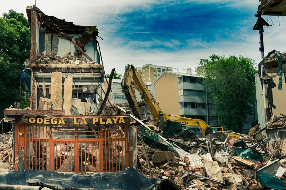
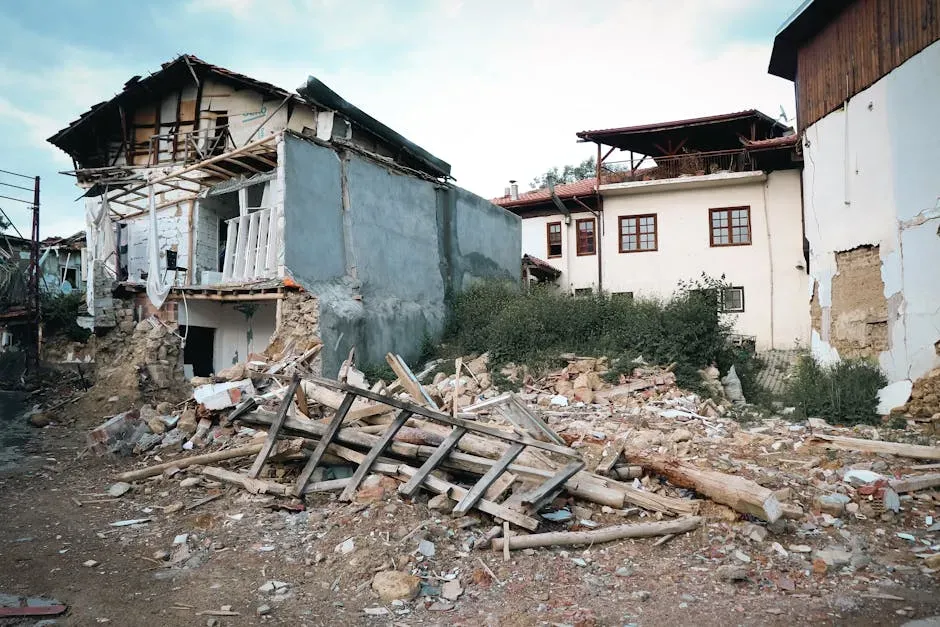
The Liquefaction Problem: When the Ground Becomes Quicksand
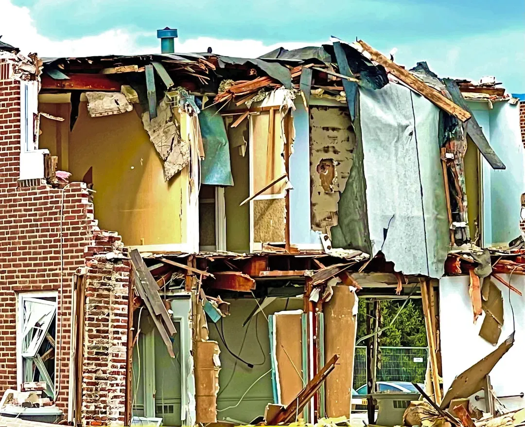
Soft sediment is prone to a process called liquefaction, a state where saturated earth stops acting like a solid and starts behaving like a liquid, similar to quicksand. Liquefaction can cause structures to tip and water mains to break, limiting the ability of firefighters to suppress earthquake-caused fires. It’s one of the most visually dramatic and destructive secondary effects of a major quake, and many buyers have never heard the term.
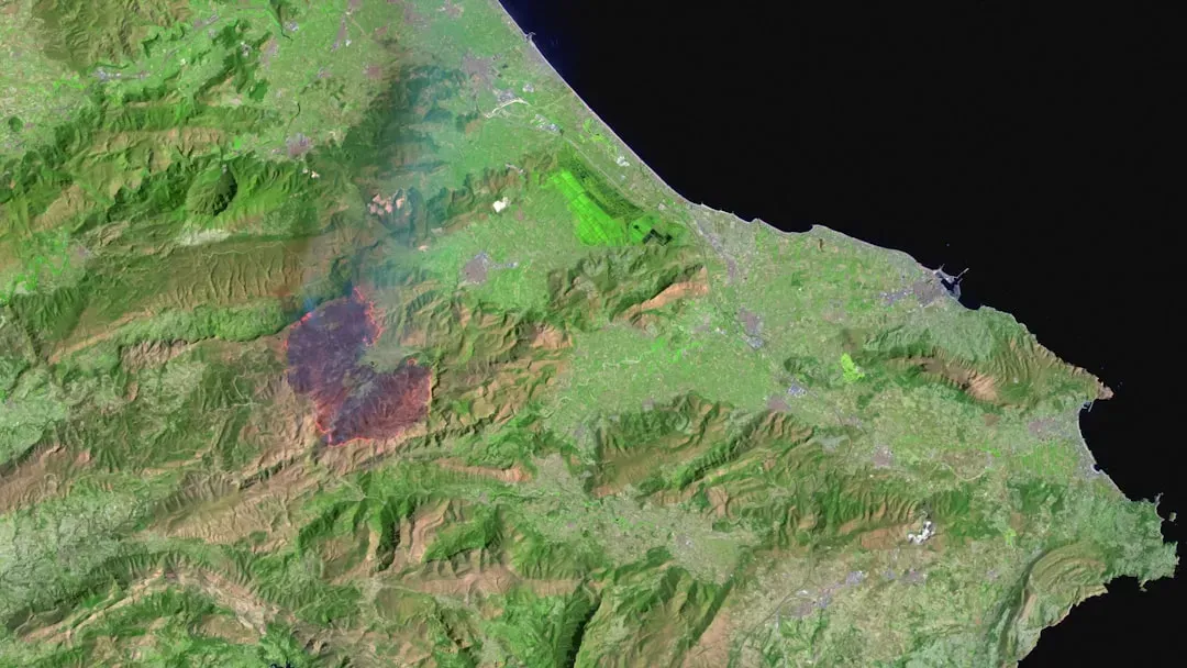
A USGS estimate reports that roughly one quarter of the San Francisco Bay Area is susceptible to soil liquefaction, and the Los Angeles area is also a high liquefaction zone. The majority of structures have not been built to withstand the additional force from liquefied soil, and many structures on liquefiable soils were built before those locations were a known hazard. That’s a significant exposure hiding inside otherwise attractive markets.
Why Being Far From a Fault Doesn’t Mean You’re Safe
Being further from a fault does not mean you are at less risk from seismic hazards. Damage is often directly related to areas prone to severe ground shaking and liquefaction. Knowing you’re in or near a fault zone is important, but so is knowing what kind of soil, or rock, your property is on. This is a point that catches even well-informed buyers off guard.
Soil conditions, building age, construction type, and local geology all affect how much damage an earthquake can cause. A moderate earthquake on soft river sediments can do more damage than a larger one on solid bedrock. That’s why site-specific data matters more than regional generalizations. The distance to a fault line on a map, in other words, can be deeply misleading without knowing what lies beneath the property itself.
The Cascadia Subduction Zone: A Pacific Northwest Reckoning

Perhaps the starkest concern on the West Coast is the likelihood of a tsunami accompanying a Cascadia earthquake. Subduction quakes are the main cause of tsunamis, and the coast from Oregon to British Columbia would be extremely vulnerable to a massive wave of ocean, debris, vehicles, buildings, and trees. Coastal communities in this region carry real estate values that don’t always reflect this exposure.
The older, colder crust in the central and eastern United States allows earthquake waves to travel much farther and thereby affect much larger areas than earthquakes of comparable size in the west. The New Madrid seismic zone, which stretches from just west of Memphis, Tennessee, up into southern Illinois, is a prime example. Earthquake waves tend to be amplified by the soft soils of the Mississippi Valley, adding to the intensity of shaking experienced by communities there.
How Hazard Zones Move Property Values in Unpredictable Ways
In a booming market, liquefaction zones barely register as a concern. Buyers are competing fiercely for limited inventory, emotions are running high, and the last thing someone wants to hear when they’ve finally found a place they love is that the soil underneath it might not behave well during the next big earthquake. Market heat, it turns out, suppresses geological caution almost entirely.
A liquefaction zone that nobody mentioned in a frenzied market can, in a softer market, become a negotiating chip, a reason to walk, or a justification for a lowball offer. Sellers who were fielding multiple offers above asking a year earlier find themselves explaining away a geological map to skeptical buyers who have all the leverage. In many instances, this suppressed demand can result in reduced property values, especially if there’s a high inventory of unsold properties in such zones.
What Buyers Should Actually Do Before Signing
Every property consists of a unique combination of geologic and structural factors that must be considered to determine what might happen to a house during an earthquake, and therefore an individual site study is necessary. A geotechnical assessment is not a luxury for high-risk buyers. For anyone purchasing in a seismically active region, it’s the single most important due-diligence step that most transactions skip entirely.
Having a certified home inspector, licensed building contractor, architect, or engineer inspect the house and give a report on earthquake weaknesses and an estimate of costs to strengthen those weaknesses is essential. Hiring a licensed geotechnical engineer or engineering geologist to check the stability of the land under the house provides an assessment that should include a geological map showing the locations of known fault traces. California’s online Earthquake Hazards Zone Application allows anyone with a computer, tablet, or smartphone to check whether a property is in an earthquake hazard zone by typing in an address or using location capability to determine whether a property lies within any of the mapped earthquake hazard zones. Tools like this exist. Using them before closing is simply responsible ownership.
Insurance, Retrofitting, and the Cost of Knowing
Insurance premiums have jumped dramatically in recent years, with national averages up roughly eight percent or more, and disaster-prone zones like Florida, California, and Midwest hail areas seeing hikes of twenty to fifty percent or higher as insurers exit or reprice climate risks. Earthquake coverage sits on top of that, and in high-hazard zones it can be substantial.
Homes that have invested in strong safety measures, such as earthquake retrofitting, fire-resistant materials, or flood barriers, might become more desirable. Such enhancements not only offer peace of mind but also translate to tangible benefits like reduced insurance premiums or increased property longevity, meaning sellers can demand higher prices for homes that have demonstrable safeguards against prevalent natural hazards. In a market where geological risk is increasingly priced in, retrofitted homes are becoming a distinct category of value rather than merely a precaution.